Frequently Asked Questions
Last year we celebrated the opening of the new Tahoe East Shore Trail, a path that received over 1,000 visitors a day in the following months. With unrivaled views, an 810-foot long bridge, and beautiful vista points, it quickly became a highlight for many visitors and residents. The trail has been successful in providing safe access to the east shore with an accessible trail that provides exercise and enjoyment of the Lake to a diverse group of users.

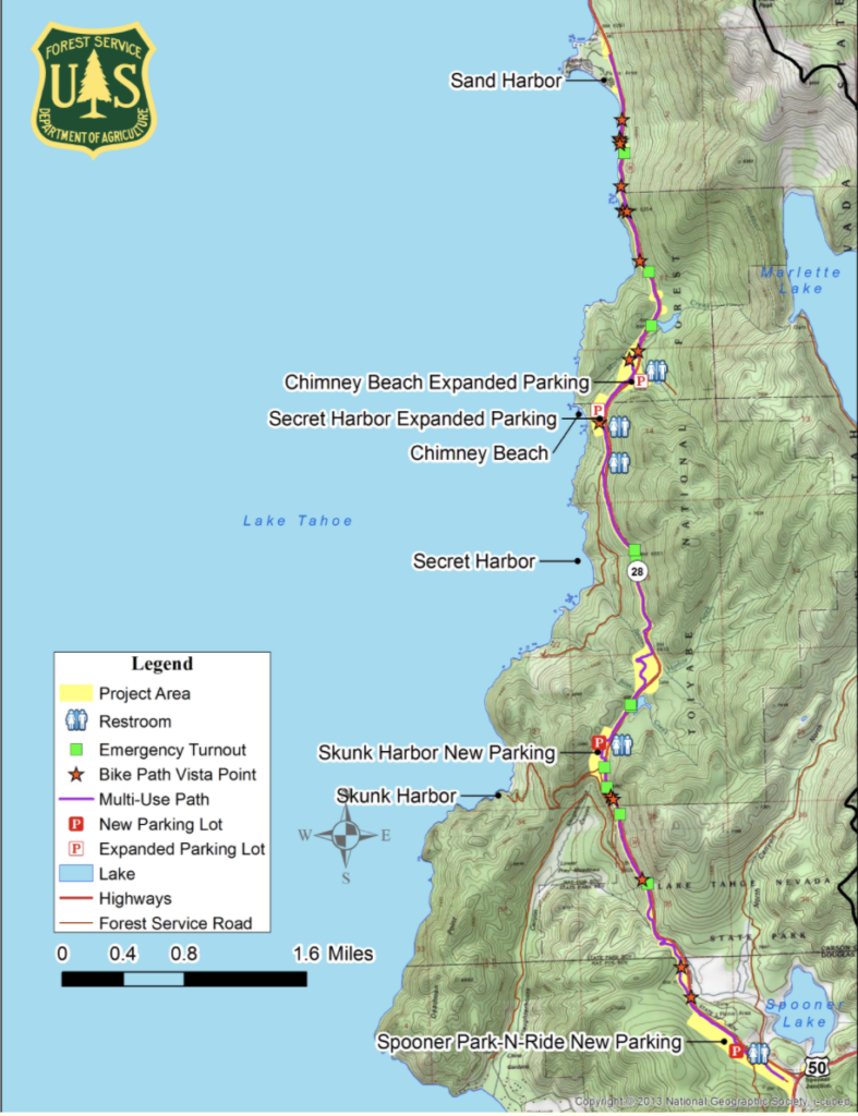
Plans are now underway for the next phase of the Tahoe East Shore Trail, extending from Sand Harbor to Spooner Summit. Project partners at the Tahoe Transportation District, Nevada Department of Transportation, and the US Forest Service, are finalizing the environmental approvals and preliminary construction schedule for the next segment.
This next phase will expand the Highway 28 safety improvements, shared-use path, parking, transit stops, emergency pullouts, visitor amenities, and other environmental improvements.
We know there are a lot of questions about this next section. Here are some answers to the ones we hear the most frequently:
When Will Construction Start on the New Section of the East Shore Trail?
- Unfortunately, Covid-19 delayed many grant requests. Right now the agencies are hoping to begin construction on the new parking lots and next new section of the path in 2023. Construction will likely take place over 5-7 construction seasons, ending in 2030.
Is IVGID’s Effluent Pipeline Replacement Part of the Project?
- It is unclear at this time. If the IVGID Board of Trustees approves and if timing aligns, the environmental analysis would allow the co-location of IVGID’s pipeline replacement. IVGID’s current pipeline runs under Highway 28 and in some area is more than 50 years old. It often requires emergency maintenance that is expensive and requires closure of Highway 28. Doing the projects together should save on construction timing and costs.
- The new pipeline will run in conjunction with the path for the majority of the alignment, transporting treated wastewater from the District’s water resource recovery facility to the disposal point at the wetlands in the East Carson Valley. The project partners have developed project timelines that match IVGID’s priorities for replacement of the pipeline.
What About Parking?
- In addition to the 91 parking spots now at the North end of the trail, the Tahoe Transportation District received funding from the Tahoe Fund and public sources to complete approximately 90 additional parking spaces along Highway 28 in Incline Village. Construction is scheduled to begin in 2023.
- The current parking at Secret Harbor and Chimney Beach will be expanded with approximately 105 and 140 new spaces respectively. Construction is estimated to take place in 2024.
- The US Forest Service also plans also include a new parking lot at Skunk Harbor with an estimated 40 new parking spaces. Construction is timing is based on future funding availability.
- There are plans for a new parking lot across from the Spooner Lake State Park entrance that will hold approximately 250 vehicles.
- In total, there will be approximately 535 new parking spaces in the corridor from Sand Harbor to Spooner Summit. During peak periods, there are currently more cars parking on the shoulder than the amount of spaces that can be provided due to the physical constraints within the corridor. The plan is to provide transit stops at each of these locations to fill the gap during peak periods. This is to meet existing visitor recreation access and not to encourage greater access to the beaches and coves.
How Long Will the New Section of Trail Be?
- The new section of the East Shore Trail will run from Sand Harbor to Spooner Summit and will be 8 miles long. Adding to the existing 3 miles of trail that currently runs from Incline to Sand Harbor, the trail will be a total of 11 miles when complete.
- The new section of the trail from Sand Harbor to Spooner Summit will be on the lake side of the highway and will follow the route of the highway and not the edge of the shoreline.
What About the Boat Inspection Station at Spooner Summit?
- The project will provide a permanent Aquatic Invasive Species boat inspection station location near Hwy 50.
Will There be Donor Recognition Opportunities?
- In short, you bet!
- The new section of the path will feature more trout, more bears, and more vista points, giving donors the opportunity to once again leave their legacy on the trail in a unique and inspirational way.
- Tahoe Fund will announce new vista point opportunities in 2023. If you are interested in reserving a vista, please email Karolina at khedman@tahoefund.org.
What About the Next Sections of the Trail?
- The goal is to one day circumnavigate Lake Tahoe with the Tahoe Trail. As of today, 35 miles are complete.
- On the Nevada side, the Tahoe Transportation District is working at both the north and south ends of the Nevada section. On the south end, the Tahoe Transportation District is working on a ½ mile connection from the casino resort core to the existing Rabe Meadow trail, as well as a 3 mile extension of the trail from the U.S. Forest Service’s Round Hill Pines Historic Resort north to the Zephyr Cove Resort & Beach.
- In addition, on the north end the Tahoe Transportation District is currently seeking grant funding to complete the 3 mile segment from Crystal Bay to Incline Village. The Environmental Analysis and 30% preliminary engineering for this segment of trail is planned to begin in 2021. As with all aspects of the trail plans, the impacts of Covid-19 may delay Tahoe Transportation District’s ability to access grant funds.
- The Tahoe Trail continues to be a lakewide effort involving many interests and jurisdictions around the Tahoe Basin.
How Can I Find out More?
Recently the US Forest Service released the Environmental Assessment on the proposed section of trail from Sand Harbor to Spooner Lake. You can also visit Tahoe Transportation District website at www.tahoetransportation.org
